
Heading South
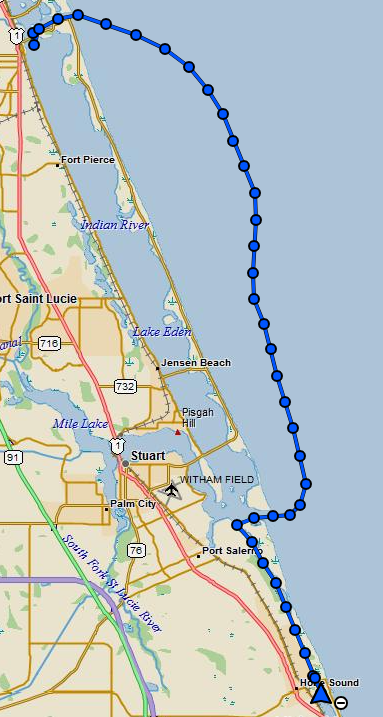
Monday morning dawned with no new options open to us. We were tied up at the city dock in Fort Pierce but needed to move since it is not meant for any extended stays. It was time to move.
We finished up the eggs with some toast cooked on the camping stove in the cockpit, and then I started calling more marinas. Some hadn’t been open over the weekend so I had some hope that I’d find a spot. There was also a marina, Riverside in Fort Pierce, that had told me that they should have an opening on Tuesday morning and to call them back. I’d tried repeatedly all weekend to reach them but they never answered the phone again. I called Riverside a half-dozen times, no answer. I tried other marinas further south down to Jupiter and beyond, no openings. One marina said they had open mooring balls but I wasn’t keen on that idea.
Finally, in desperation about 9 AM, we decided to head south and try to find an anchorage just off the ICW (Intracoastal Waterway) within sight of where several friends live. There are anchorages all up and down the ICW, but I didn’t want to just leave it anchored somewhere. Perhaps they would be willing to glance at it once in a while to at least see if it was still floating and not having everything stripped off her by thieves.
We eventually untied all the dock lines holding Strider in place and set off down the ICW. We passed under the Fort Pierce South Bridge and into the large open area between Hutchinson Island and the mainland.
Hmm, the channel didn’t seem to be marked. The ICW is fraught with peril for us because we need so much water. If we stray off the channel, we’ll go aground. We scanned the water but couldn’t spot channel markers. I did see a buoy up ahead and slowly made towards it, but as we approached, I kept saying “that looks awfully shallow up there, that sure looks shallow…” Thud. Yep, Confirmed, shallow… They say there are two kinds of sailors, those who have gone aground and liars. Well, I’ve joined the club now. Fortunately, just into soft silt.
I backed out of the silt and into the slightly deeper water. We scanned the horizon more, where were the channel marker buoys?
A motorboat headed north hailed us on the radio to be sure we saw him and we asked where the channel was. I didn’t understand his answer. We called a friend familiar with the area and asked him and his advice was “don’t try it.”
OK, enough with the ICW, we headed back under the bridge, out the Fort Pierce Inlet and out to sea. It may be a bit rougher out there, but at least I can have a comfortable 50-100+ feet of water under my keel and not be constantly looking for those faint brown patches meaning I’ll likely go aground.
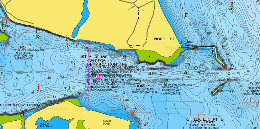
Our destination was the Port Saint Lucie Inlet, 23 miles south, which we made several hours and a peanut butter and jelly sandwich later. The navigation charts for this inlet say to take great caution since there is constant shoaling. Because of the large amount of water coming and going with the tide which moves around a lot of silt, any chart is going to be out of date very quickly.
ICW Second Attempt
The charts say to consult someone with local knowledge, so, at the entrance of the inlet I approached a pontoon boat with two fishermen and called over to them asking the depth. One of the men said he thought it was 16′ deep. Well then, no problem!
We started into the inlet very slowly, watching the depth finder. 16′, 14′, 12′, 10’… Umm, OK, we’re good at 10′ but that’s a bit shallow for my liking. However, the channel was well marked with movable buoys so it appeared someone was monitoring and keeping them up to date.
Still watching the depth gauge carefully we followed the marked channel. Then the depth finder went blank. Great, the house batteries took that opportunity to shut off. Apparently the breaker had tripped again and the batteries had gone dead on the journey from Fort Pierce. Well, no going back now. Sticking to the center of the marked channel we very slowly made our way to the ICW and turned south towards Hobe Sound.
ICW Stuart to Hobe Sound
This was our first journey on the ICW that wasn’t a wide bay with a marked channel. Along much of this stretch it felt like we were on a river about 400′ wide, but with a narrow channel marked, perhaps 150′ wide. There was plenty of room and generally while passing through one set of markers, the next set was easily visible.
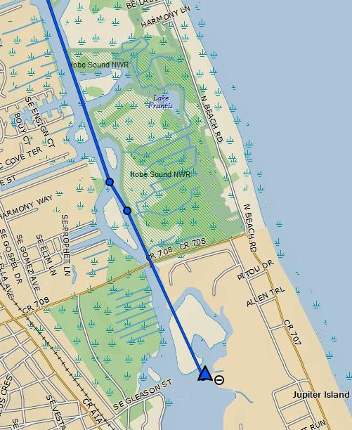
And so we made our way the 7 miles down the ICW from Saint Lucie River Inlet and to the area close to our friend’s home.
Need more water!
As we approached the small channel that I was hoping to anchor, I was studying the sonar charts carefully, trying to thread the needle into the area that was just deep enough for us. I hoped to anchor in the orange circled area, but I knew that the red area was going to be very close to too shallow. The marked depths are supposed to be at low tide so I was hoping to sneak through at high tide.
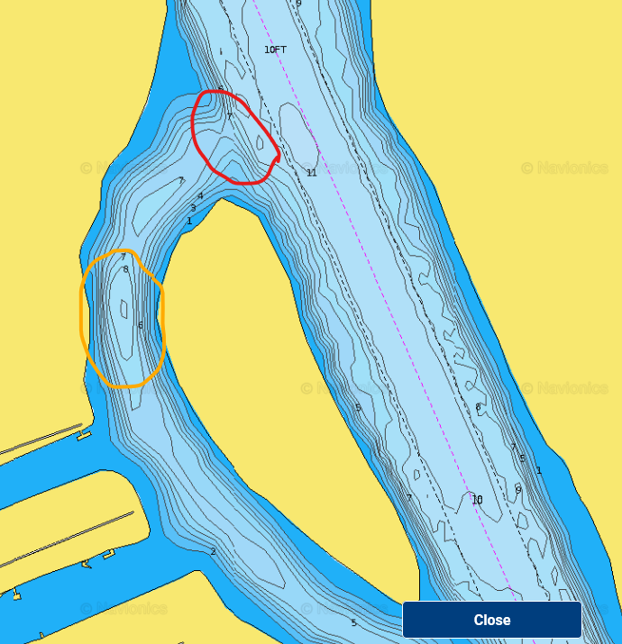
Arriving at the red area, we very slowly tried to ease into the channel, but without a functioning depth finder, we were blind. Almost immediately we went aground. We backed off, drifted further south and tried again, and ran aground again. We couldn’t find a deep enough entry to pass into the channel. So much for that option.
This is quite close to the Hobe Sound bridge and there was very little room here to get out of the channel but still in deep water. We made a snap decision and decided to proceed further south to find an anchorage for the night.
I called the bridge on my cell since, with the batteries, my radio had also gone. “Hobe Sound bridge, Hobe Sound bridge, this is the south-bound sailing vessel Strider requesting an opening.”
“I see you Strider and will open the bridge when it is safe to do so.”
That is all there is to it. When we left Miami the idea of passing through drawbridges and navigating in that “narrow” river was intimidating. Now it seemed almost an after-thought. I guess there was a little bit of growth in the crew after all.
Just south of the bridge I could see a large area that looked like it had enough depth. We passed through the open drawbridge and made for this area.
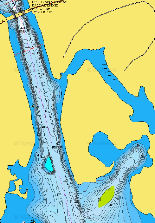
We made our way into this small bay and dropped the 65lb CQR anchor. The wind was out of the west so we dropped it close to the 11′ depth marker on the chart. With the anchor down we played out about 50′ of chain, hooked up the snubber and were at home-sweet-home. Our location was 27°03’31.9″N 80°07’07.7″W.
We spent the last two hours of daylight securing the snubber and trying to make sure everything was as it should be. This was our first time to use the anchor so we had to figure out how it had been rigged, where the snubber was stowed etc.
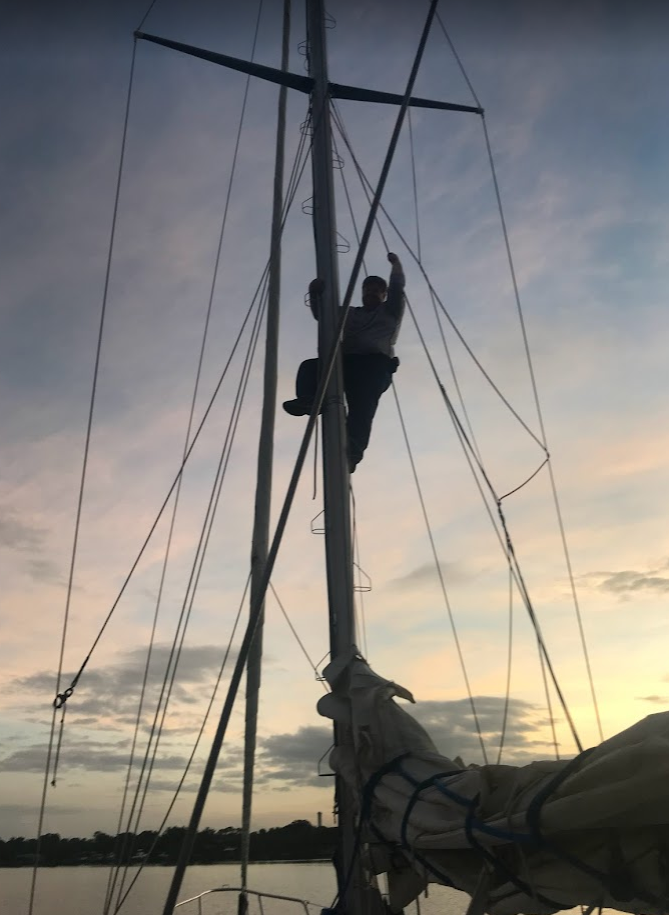
Then, I climbed up to the top of the bridge on the aft of Strider and untied the rope holding the wind generator stationary, hoping to get a bit of charge from it (as far as I can tell we didn’t…). I also climbed the main mast and retrieved the bitter end of the spinnaker pole line which was about half-way up. Finally we could get the pole off the deck and back where it should be.
We ate some canned stew and tried to settle in for the night. It was too hot to sleep below so we bunked in the cockpit. The mosquitos were well fed that night! If I’m honest, there wasn’t a lot of sleep. I was quite anxious about dragging the anchor and going ashore in the middle of the night. This, the mosquitos and my mind spinning trying to think of SOME option kept me awake almost all night. On the plus side, the wind was pleasant and the stars were bright as I lay under them, shooing away pesky little beasts and pondering.
My hope for the day hadn’t played out and we still had no place to leave Strider.. Again we were out of power and I couldn’t think of any options. It was getting quite easy to feel sorry for myself despite being on a beautiful boat in a lovely anchorage. Life is tough! 🙂